SandT enjoys a well-earned summer break

Dear readers,

as of today, SandT will be having a summer break. The next adventure directs myself to the Indonesian islands Bali, Lombok and Flores (yay!!!) for three weeks of snorkeling, cultural experiences, Komodo dragons and and and… so keep tuned, there will be lots of new stories coming up in September.

Bild

Posted in Uncategorized | Leave a comment

Rigi, queen of the mountains: my first ascent of a mountain following Mark Twain’s footsteps


TrekkingThe American author and humorist Mark Twain became famous for writing the Adventures of Tom Sawyer and Huckleberry Finn. He also wrote funny and entertaining short stories on the brink of what became typical holiday tourism these days. Mark Twain and his family spent a summer in the area around Lake Lucerne, in Weggis, in 1879 and he is thrilled about it: “This is the most charming place I have ever lived in!”

DSCN1967

Checklist time:

  • Roundway: Jepp, up by foot and down with the gondola.
  • Accessibility: Weggis
  • Length: 1400 hm, app. 4-5 h
  • Strenuousness: High (but not highest :-))
  • View: Great
  • Loneliness: No.
  • More information: Mark Twain Themenweg (German only)
  • When did I go there: August 2013

Wandervorschl17_2012.inddHere you see a very rough sketch on the trekking route (click for large image). The map is courtesy of Wellness Hotel Rössli.

The hike starts at the lake front in Weggis next to a Mark Twain memorial stone. From there, we walk a short way through the village to the gondola station and into the forests. The path runs quite steep at the beginning and sometimes you even have to walk up stairs. Despite the steepness, the trail is easy and broad and not really alpine style. Just take good hiking shoes with you.

Through shady forests we walk and encounter lots of pretty small waterfalls. The day is part sunny / part cloudy and the trees and small streamlets give ample protection from the sun and the heat. On this pic, you see the Titlis glacier peeking through the clouds.

DSCN1968

Between the rocks, there is a small chapel overlooking Lake Lucerne and shortly after, we reach Felsentor (rock gate): a passage through three interlocked huge rocks. The accompanying settlement (a main house, sheds and a huge garden) are used for group retreats and meditation courses. You can also get some delicious home-made sorbée: om-nom-nom!

Having passed Felsentor, we head into the open and the trail is not too steep until  Rigi Kaltbad is reached. Rigi Kaltbad is indeed a small village with several restaurants and hotels. Both the gondola and the cog railways from Vitznau and Arth-Goldau meet here. There is also a thermal spa there, designed by Mario Botta, who is known, among others, for having designed the MOMA in San Francisco. I visited the thermal spa in Rigi Kaltbad this january and I just realise it’s missing the respective SandT post. When we went there, there was an association meeting going on, which was really interesting to see.

From Kaltbad (and another home-made sorbée), we take a small detour towards the summit Rigi Kulm to pass by a nice view point, the Känzeli. Here, it is rather crowded as Kaltbad, Kulm and Känzeli are the most touristy places on Rigi. The view is great though and we make good progress – although the path is getting a little steeper than before.

DSCN1974

It is hard to distract the boys from all the restaurants we pass, but there is no food or a rewarding summit beer to be had before we actually reach the top. And so, after 4 h 10 min and 1400 hm, we made it all the way up to Rigi Kulm -yeah! My first mountain is conquered!

DSCN1980And then, we sit down to enjoy a cheeseburger and a beer – well-earned, I dare say. We even spot one of the very old steam engines that were used in the times of Mark Twain and still need to work every sunday.

DSCN1985Apropos, Mark Twain: there are several Mark Twain info signs on the way, which we tried to photo-hunt to document our Mark Twain Rigi summit hike, but we missed two out of eight (Kulm and First) – seems like I have to go up there again and take a picture of the other two. That’s how they look:

DSCN1950After a sufficiently long relaxing and recharging break, we take the gondola from Kaltbad to Weggis and head home. It turned out, we all had a date tonight to attend to – with our couch.


Posted in Switzerland, Trekking | Tagged , , , , , , , , | Leave a comment

Outdoor rock climbing for beginners


15167702-black-silhouette-of-a-rock-climber-on-a-sunset-backgroundNow, ladies and gentlemen, honoured readers, it’s time to go to the rocks – high five! 

After spending two evenings in the indoor climbing hall, we went to a rock area called the Rivella trail near Lucerne, CH – between Hergiswil and Stansstad just next to the lake. Outdoor climbing is a little different from being indoors. First of all, at indoor climbing, you go the route of your choice and follow these specific grips. On the rock, you choose from many different grips, they are not pre-defined. You need to feel the rock with your hands and feet constantly to see if you can get a good hold there.

4

In addition, ropes are provided in most halls. Outdoors, you need to bring your own rope and someone with experience will climb up first (Vorstieg) and tie the rope with special sophisticated knots at the summit. During the climb, the volunteering lead climber uses a set of quickdraws (Expressen) to secure himself at numerous bails already hewn into the rock in case he falls before reaching the top. Also, bring a helmet to protect yourself from falling stones.

6

And then, we mean business. Our lead climber and adviser picks a rather easy route to get the feeling and soon we are all in the wall climbing.

3

We did a tour called Chli Kante (small edge, number 31) with difficulty of 3b to start with and then the Keep Left trail, a 4c (number 1 in the picture).

8The nice thing about Switzerland is, you also have an amazing the view from the top of your climbing trail. If you manage to get a good stand (or maybe you can sit in the gear secured by your partner) and if your hands aren’t shaking to badly (which they most likely will do), you can manage to shoot some pics from up above from. Although they will not reflect the great feeling you have after having managed to climb all the way up and being rewarded with a stunning lake view. I did manage to shoot a pic after a few minutes of getting my breath back – although I made sure to keep both hands on the phone.

2The trip was great. Unfortunately, it gets dark to quickly after work – this definitely calls for a repetition on a weekend. Today, at this very moment, it’s raining cats and dogs and you can hear the thunder echoing in the mountains. This means indoor climbing, folks!

5

Posted in Rock climbing, Switzerland | Tagged , , | Leave a comment

Indoor rock climbing for beginners

15167702-black-silhouette-of-a-rock-climber-on-a-sunset-backgroundOne of the first things that comes to mind when you hear ‘Switzerland’, it is most likely the mountains. Huge Alpine silhouettes accompany you almost always (except in the case of foggy weather), you get used to the form of their summits and greet them like old friends. And, as time goes by, just watching the mountains from below is not enough. You want to get to the top. Or down there, preferably on skis.

A really fun way of going up is climbing and as I had the opportunity to get a climbing introduction, I didn’t hesitate at all and a few days later three absolute beginners met with an experienced guide in an indoor rock climbing hall near Lucerne. This article is not meant to give you an introduction that you can follow to really learn climbing and rather to get you interested and look for someone who knows what he or she is doing to teach you the basics.

DSCN1592

How to start / basic equipment

As said, as a first thing, you need someone with experience. Rock climbing is quite save if you do it right but first you have to know how to do it. In addition, you need a climbing harness, long comfortable trousers and climbing shoes, which are called Finken in Swiss German. Normally the gear can be rented at the halls and ropes are provided for the easier routes as well.

To the wall

Once you managed to get on your harness correctly, you can start boarding the wall. Your harness is connected to the rope, which, via a linkage at the top, can be tracked back into the caring hands of your climbing partner. She/he is responsible for securing you when you fall and for getting you back down to earth once you made it to the top. So make sure it’s a reliable person.

??????????

The indoor rock climbing halls provide different routes with varying difficulties. The routes are colour-marked and you should try to use only the grips in your colour of the route. I picked the yellow route, as you can see in the pic below. And then, off you go.

??????????

There are a lot of cleverly contrived tricks to ‘do the wall’. Keep your body to the wall, work mostly with your legs, cleverly shift your weight and sometimes you just have to be brave. It’s fun trying out if the different technique you have in mind actually works. If you fall, you are secured and you might even get back to the wall and try it again. Or call to your partner to give you a break and sit down in the harness to relax.

??????????And then, you are there. The top of the route! The roof! Unfortunately, it’s not very comfortable up there and there is no way to sit down, have a coffee and enjoy the view.

??????????Rather, sit down in the climbing harness, get your legs straight and you will be ‘abseiled’ – some people pay money just for that.

??????????

Don’t know about you and your level of fitness, I definitely had quite sore arm muscles the day after and I definitely should work on my pull-ups. Next time, you’ll get to know how it is to climb outdoors, you know, on real rocks and stuff.  See you next time. And if you’re from around and interested in a climbing partner (albeit a not very experienced one), just let me know!

??????????

Posted in Rock climbing, Switzerland | Tagged , , , | Leave a comment

What’SUP?! – Stand-up paddling at Lake Lucerne

Now, what’s that again? Yes, basically SUP is one of these new sport hypes that bored metropolis yuppies with a left-winged attitude that don’t do drugs are craving for. Make no mistake, I am one of them myself.

SONY DSC

On a warm summers eve, meaning yesterday, my company and me went for a stand-up paddling (SUP) tour around Lake Lucerne. We were the second group and started the event with relaxing in the sun and a bottle of beer, which I already found very to my liking. And then, it was up on the boards. Our instructor gave us a quick introduction and then we already went out on the Lake. The event was organised by Surfcorner Lucerne which are situated at the Lido and at the Tribschen. Photos shown here are also their curtesy & property and if you are interested in renting a SUP board or doing a tour, you find more information on their website.

SONY DSC

Basically, the SUP board is similar to a surf board. You push it into the water, scramble up the board so that you kneel on it – and then stand up. It’s quite a rickety affaire but after a while you will get the knack of it. With paddle longer than yourself you paddle standing (hence the name, surprise…) along. At first, you will fall into the water several times, either due to waves from a passing speedboat, due to a lack of attention or because one of your colleagues throw you in. We went quite far on the boards and did lots of jabberwocky on the lake. We held four boards together with the paddles and someone tried more or less successfully to run over the tips of all of them.

0403

It’s good fun and a good exercise as well. I do feel my belly muscles a day later and these are exactly the muscles I normally “forget” to exercise at the gym. SUP rent is 20 CHF per hour. So, if I got anyone interested in SUP and if you are from Lucerne or nearby, let me know. I would like to be in for another tour!

Posted in Sportsy, Switzerland | Tagged , , , , , | Leave a comment

Micropilgrimage on the Road to Santiago


TrekkingIndeed, dear reader, your eyes have not betrayed you. I went on a pilgrimage, albeit only a small one, hence the title of this blog entry: micropilgrimage.

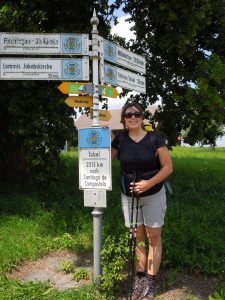
How does one come up with the idea of walking along the Road to Santiago if the last visit to a church has been countless years before and one is more inclined to believe in the Flying Spaghettimonster than in any other religious societies. I can tell you that: it’s part friendship and part curiosity. A friend of mine set herself the task of walking from her hometown in southern Germany to, ultimately, Santiago di Compostella. She started this year with her project and ended up walking through Switzerland and so I joined her for a weekend. It was really interesting and mainly I learned a lot about people, so hang on even if you are an atheist, agnostic, hindu, or muslim.

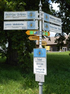
DSCN0765

Checklist time:

  • Roundway: nope; the goal is to ultimately arrive in Santiago to Compostella. You can walk all the 3000 km back on a different road if you have the stamina for it.
  • Accessibility: For the weekend tour, I parked the car at Steg, Fischenthal, SZ and took the S-Bahn to Märstetten. In general, the Road to Santiago is a star-like net of various paths that are all ultimately joined towards the main goal. So, wherever you are in europe, it’s most likely you will hit the Road pretty soon.
  • Length: approximately 40 km and 385 hm
  • Strenuousness: Middle
  • View: Up the Hörnli, the view is nice and on the Road you come to see a lot of chapels and churches,
  • Loneliness: This is an interesting question. Of course you encounter several hikers on a weekend in Switzerland. I didn’t meet any other pilgrims, but a lot of hostel wardens who already knew we were coming and told us who was ahead and behind us.
  • More information: On the Swiss part of the Road to Santiago here (in German, English and French)
  • When did I go there: July 2013

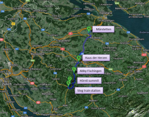
MicropilgrimageHere you see a very rough sketch of the trekking route (click for large image).

On Saturday morning, really really early, I went to the supermarket to shop groceries for the trek. Being unsure if we were able to purchase food I wanted to be on the safe side. Here’s what I bought for one person in my delusions and enforcedly carried around: 2x  500 g packs of bread (yes, 1 kg of bread), 2 packs of processed cheese (those that comes in small triangular packages; it was a special sale so of course I bought 2 packs), 1 pack of cereal bars (10 pieces), 1 pack of apricots (500 g), a chicken breast sandwich with sweet and sour sauce, 3 500 ml bottles of water, 1 bottle of ginger lemonade and, as a special treat after dinner, a small glass bottle of no-name whisky (turns out they don’t sell the good ones in small take-away bottles; what a shame…) and a package of Scottish short bread.

DSCN0758

I stuffed everything in a daypack and drove to Steg. I made it to the train station 3 minutes before the S-Bahn arrived. That means 3 minutes to change into hiking shoes, grab the daypack and the hiking poles, and buy tickets for parking and the S-Bahn – plus panick slightly because you don’t have enough change to pay the parking machine. Panick a second time because, when you try to pay the parking with the mobile phone, you don’t remember the license plate number and enter something like “this white Volvo” into the appropriate field. Plus panick a third time because you cannot actively remember locking the car. But: you are on the way now and there’s nothing to be changed now. Time to enjoy the trip!

In Märstetten, I was greeted by a beautiful sunshine weather. We easily found the Road to Santiago, which is perfectly tagged and started the journey. During lunch, a group of elderly ladies you walked a small part of the Road greeted us with an ecclesiastic song in a chapel in front of which we had lunch. My grunting about my heavy daypack made my friend suspicious and as we lifted both we found out that mine, packed for two days, was as heavy as hers, packed for 3 weeks. Uff, that’s what I call thoughtful organisation. At least we share the same burden – and we won’t starve, not in a lifetime by the amount of food I brought with me.

DSCN0761

In a lot of churches, chapels and pilgrim lodges you can collect stamps for a special St Jacobs ID pass. You cannot take many souvenirs with you except stamps and pictures as you would have to carry all of them so my friend was really protective and proud of her pilgrim ID. And she can be, as it is the written (or stamped) prove that she walked from Ulm to Bern!

DSCN1682

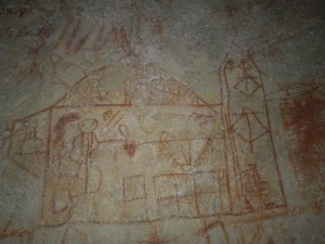
The Road goes on through fields and woods and small villages. In St. Margarethen, we found a church where several hundreds of years ago, the pilgrims seemed to have invented an early form of graffiti scribbled into the church walls. We lost our way shortly after, and a nice lady recognised us as pilgrims by the typical scallop my friend wore at her backpack and redirected us.

DSCN1689

In Sirnach we had a sleep over at the “House of Hearts” (Haus der Herzen) with Peter and Agnes, you gave us a warm welcome, a hot shower and a huuuge amount of food. Not that we didn’t have our own and lots of it as well, but vegetable soup, spaghetti Bolognese, ice cream with hot raspberries and self-made liqueur do sound much better than stale bread and warm half-molten processed cheese; wouldn’t you agree? A propos alcohol, we excused ourselves from Agnes and Peter rather early and had a lovely sit-in in the pilgrims room. Music was played from the mobile phone and we enjoyed the cheep whisky (which was better than expected) and the short bread. Yes, I know, we already had a 3-course dinner. Short bread always fits in, I daresay.

DSCN1695

Agnes and Peter also generously provided my with my own pilgrim ID pass (I didn’t have much say in it), Haus der Herzen stamp included so now I can start collecting. So, if I ever go on a micro- or even maxipilgrimage again, I already have the ID and some stamps. The whole house was full of Road to Santiago stuff with pictures and scallop souvenirs and all kinds of knickknacks. I am short of calling it an obsession and will settle for ‘a very serious hobby’.

Breakfast was equally great and we went back to the Road as early as half past 8. Not bad for a sunday, eh? The abbey in Fischeningen is a beautiful and huge building with a nice church. Legend has it that St Ida of Toggenburg lived in Fischingen. Her husband accused her of cheating, killed the would-be lover and threw her of the highest tower of his castle. She survived and henceforth dwelled in the surrounding woods. Later, her husband realised his mistake and begged her to come home, which she graciously refused. Years later, she died in her hermitage which was built by her husband and was buried in the church of Fischingen. Her grave has a kind of hole where weary pilgrims can put their feed in and be magically bereft of all foot sores. Turns out, it only works when you sit in the abbey. Once you start walking, the magic crackles and you have to do the ascent to the Hörnli all by yourself. Apart from Ida’s grave, the abbey has a restaurant, a souvenir shop and a pottery, which seemed all rather (touristy?) expensive. We were greeted by the few monks that still life there. They wished us well for the trip, but they did not offer us a hot beverage or something of that kind. Has the Road to Santiago become such a “pilgrim highway” that they cannot afford that kind of kindness? Or are my expectations to high? Clearly, just because you wear a scallop on your backpack shouldn’t grant you the privilege of getting free stuff, especially if you can afford it. But still, it would have been nice, especially for my friend who has been walking a bit longer than me.

Leaving the monastery behind, we have lunch at a peaceful bench (more stale bread and processed cheese) before we start our hike up Hörnli. On the way up, a hostel warden greets us, saying he lodged some fellow pilgrims and wishes us good luck on the Road. Carrying the scallop is like taking a cute puppy for a walk. It decreases the boundaries between people and you get in touch with many friendly persons.

The Hörnli isn’t too high (approx. 600 m) and neither steep and although my friend isn’t used to hiking up and down instead of straight ahead, we reach the summit in pretty good time. Green knee-high grass rocks in the wind and we just lie on the meadow and enjoy the sunday summer afternoon. Feels like holiday!

At the Hörnli restaurant, you can rent a scooter for 20 CHF and scoot down the hill. We prefered to walk though and encountered a kind of special breed of chicken and also a new type of aligned cows. Does anybody know why they keep walking in lines along the hill? I suggest because then they can eat the fresh grass to their left and right and don’t spoil it, although I haven’t seen any cow so smart yet. Normally they just trample everywhere until their pasture is a huge speck of mud and then hope to be relocated by their farmer.

Luckily, the descent from Hörnli immediately stops not only at the train station in Steg, but at my car. My locked car without a parking violation ticket – hurray! And never has it felt so good to get rid of the hiking shoes. My friend went on to spent the night sleeping on a straw pellet. Later on, she would have made her way to my place near Lucerne where I would also draw my very own pilgrimage stamp into her ID card, Alpen panorama included.

All in all, I spent a lovely weekend enjoying good company and new insights into the unique world of Road to Santiago addicts. I also realised that I most certainly liked the second day better, with less chapels and roads and more height meters, nature and views. I guess a pilgrimage along the John Muir Trail would suit mr much better! Has anyone of you done the Trail (or part of it)?

DSCN1688

Posted in Switzerland, Trekking | Tagged , , , , , , , , | Leave a comment

Crossing the suspension bridge and a quick hike at Sattel-Hochstuckli

TrekkingThe village of Sattel nestles against a mountain range that is constituted by the summits of Morgartenberg, Chaiserstock and Hochstuckli. The landscape has been noticeably formed by moraines during the last ice age. The Mostelberg directly at the mountain station of the cable car has a very long suspension bridge that spans the beautiful valley of Lauitobel and is up to 58 meters high. In June 2013we plan on crossing the bridge, going on a walk and having lunch at one of the cozy mountain restaurants. Unfortunately, it was raining cats and dogs. But this didn’t stop us…

20130629_102300

Checklist time:

  • Roundway: yes
  • Accessibility: Via car to Sattel, park at the valley station of the cable car (parking for free) and take said cable car to Mostelberg.
  • Length: 5 km and 385 hm
  • Strenuousness: Low
  • View: Mystique if you pick foggy and rainy weather
  • Loneliness: Turns out, if it is raining cats and dogs, hiking paths seem to be rather deserted.
  • More information: Sattel-Hochstuckli (German only)
  • When did I go there: June 2013

Panoramakarte_Sommer_2013Here you see a very rough sketch on the trekking route (click for large image). The map is courtesy of Sattel-Hochstuckli webpage.

We crossed the suspension bridge (yellow) and then took the route number 4 up to Hochstuckli summit. It wasn’t raining yet, merely being cloudy and foggy, so I left my rain trousers in the backpack, which will turn out to be a bad decision.

Crossing the suspension bridge is quite an adventure. It is really long and you can see through the metal meshes on the floor down to the ground. It sways in the wind because it is hold by thick cable wires. It also sways when people are jumping up and down on the bridge. It was fun for me although I guess people without a head for heights would be a bit daunted. Can you spot the bridge in the next picture?

20130629_102858

Once we crossed the bridge, it was half past 10, which is a little early for lunch and the idea of having second breakfast has never really made it into Swiss hearts. So, we decided to hike up to Hochstuckli peak. By this time, the rain increased and we made our way along muddy paths and even around a herd of cows (plus their soaked left-overs). One cow even decided to follow us quite a while. Maybe she hoped that we would spare our rain coats with her or she mistook us for the farmer and hoped to be brought back to her shed.

Despite being wet and muddy, the view was still worth it. The Hochstuckli summit is opposite the Mythens (see my post for Hiking up the Grosser Mythen) and this time mystic clouds blanketed the ascending rocks which generated a quite arcane atmosphere. We didn’t stay long to enjoy it though. Remember, it was still pouring rain, so we had a quick mountain snack (tap water and cereal bar) and headed back to Mostelberg. I didn’t put on my rain trousers, so I was soaked at the legs when we arrived, but still dry everywhere else. As someone put it so nicely, there is no bad weather, only bad clothing (and next time I’ll definitely USE my rain trousers and not just carry them around).

20130629_113600At the restaurant we enjoyed our well-earned Alp lunch and one or two Kaffee Träsch. Kaffee Träsch is a coffee speciality well-known throughout Switzerland. It is very thin coffee with a certain type of schnaps (Träsch) and a large amount of sugar. I guess you drink it in Switzerland as the equivalent of mulled wine. Very good though and best to warm you up after a wet and cold day.

Posted in Switzerland, Trekking | Tagged , , , , | Leave a comment

Hiking up Grosser Mythen

TrekkingThe sister mountaines Grosser and Kleiner Mythen (big and small Mythen) are the emblem of Kanton Schwyz and you can spot their distinctive summits from a lot of places in Schwyz. By the way, the country Switzerland (Schweiz) has its name from the aforementioned Kanton Schwyz. Although spelled differently in high German (Schweiz und Schwyz), the pronounciation can be somewhat similar in Swiss German.

Mythen, which has the same name as the German translation of legend, is named after the Latin “meta”, which means “something looming”.

The Grosser Mythen can be hiked by a steep path that starts in Brunni SZ (SZ is the abbreviation for Kanton Schwyz similar to the abbreviations used for the States in the US).DSCN1587

Checkliste time:

  • Roundway: nope – you hike up the mountain and come down the same way
  • Accessibility: By car, drive to Brunni SZ. There is a large parking place at the valley station of the cablecar.
  • Length: 6 km and 800 hm
  • Strenuousness: High. The path is very steep and narrow and you have to cover a lot of heightmeters. You should have a head for heights as well.
  • View: Unique
  • Loneliness: Nope, sorry.
  • More information: Mythenweg (German only)
  • When did I go there: June 2013

MythenHere you see a very rough sketch on the trekking route (click for large image).

From Brunni, you can already see the impressive Mythen. Head into this direction (surprise…). Shortly after, you enter the forest and it already starts to get a little steep. If you want to cut some distance, take the cablecar to Holzegg. Leaving the forest, you will arive at Holzegg anyway. There is a small restaurant there that has a nice view and a toilet. Even though it is supposed to be just for guest, try to keep in mind that this is the only protected place where you can relieve yourself until you reach the summit.

After Holzegg, fun is over. The nice foresty path turns into steep Alpine gravel and rocks. Although the way is secured with chains at the most dangerous parts, take care. Most of the time, it’s rather narrow and it is a long way down. You will see dogs and even children on a leash to protect them from falling. Don’t be afraid though, as I said, the path is well-mended. Once the curvy part begings, have a look at the numbers in each curve. There are 43 curves going up Mythen and you can nicely stay updated on your progress. The view is beautiful and it might be a bit crowded at the week-ends. Most of the Swiss people have already been up Mythen and you get the impression it has become a kind of outdoor-pilgrimage. Even in June, there were small patches of snow near the peak.

DSCN1593

And then, after an exhausting trip with many curves and much more heightmeters, you are there: the summit! There is a small restaurant at the top where you can enjoy a well-earned cold beverage – if you like to pay for it. Food and drinks are transported by heli to the summit and accordingly expensive. Here are some nice pics from the top:

Once you adequately enjoyed the great view and regained your breath, head down the way you came. We took the cablecar on the last part to give our knees your break. You might want to treat yourself with a very delicious ice coffee at the Restaurant Brunnialp. It contains large cones of coffee ice and a generous portion of cream. In addition, you can enjoy your ice coffee while marveling at the peak, which a) looks quite high from here and b) you know you just managed to walk all the way up. Feeling of success, yeah!

DSCN1609

Posted in Switzerland, Trekking | 1 Comment

Hiking the Azores – Everything BUT Hiking

a10_h_34_5026The Azores generously provide a large variety of diverse hiking trips, along the Atlantic ocean’s coast or in the middle of the island through forest thickest that almost makes you forget that you are on a small island in the middle of nowhere basically. Apart from trips to vulcanic crater rims and beautiful views, there are lots of things to see and do on Sao Miguel. Here are some ideas and tips for your next trip to the Azores:

  • Cha Gorreana,
  • Hot springs and vulcanic meal at Furnas,
  • Bathing in a warm waterfall,
  • Ecologic pineapple plantage,
  • Ponta Delgada shopping mall Parque Atlantico.

Cha Gorreana
Tea, either black or green as the same plant is used for both (also for white tea, by the way) is typically grown in Asia and some names stem from their Asian origin, like Assam or Darjeeling. There is one and only one location in Europe that grows tea and, as you might imagine, this is Sao Miguel. A couple of hundreds of years ago, the local tea was exported mainly to the UK (surprise… :-)). Nowadays it is mostly grown for self-use. For a long time Cha Gorreana was the only tea company and just recently it got some minor competition. Cha Gorreana, both the manure and the plantages, huddle against the gentle slopes of the north coast of Sao Miguel and the tea plants gently sway in the sea breeze.

DSCN1428

It is easy to find, normally. For some reason we ended up driving up to Gorreana by a backside gravel road through road holes and a flock of chicken which already got us into farmlife mood.The plantage consists of several houses, one of which contains the whole processing machines, a cafe and souvenir shop. There are also several living houses. The entrance is free, you are aloud to have a look at the whole manufactury and for a small tip, you can visit the local women sorting the leaves.

You can try the green and black tea produced at Cha Gorreana directly there and also free of charge. If you like it, you can buy some at the souvenir shop. It is cheapest there, but Cha Gorreana tea is also available at supermarkets all over the island. You will notice that the tea is very mild and not so bitter and has a different, more ‘planty’ taste than the standard tea you are used to. It is definitely worth a try and I am actualy having some Gorreana tea I broght with me to Switzerland at this very moment while writing this blog. Her is a pic of the plantage with the sea in the background:

DSCN1433

Hot springs and Cozido at Furnas
Furnas, which lies next to Furnas Lake in the middle of the island (see Azores tour #4) is gifted with several hot sulfuric springs due to vulcanic geothermic activities. A collection of several springs with surfacing boiling water can be found just at the vicinity of the village. A small wall keeps visitors from getting too close. Not only the springs are boiling but the ground around is very hot as well. You can take a stroll through the several places where the stinky water reaches the surface (entrance and parking is free) and bath in the sulfuric steam originating from the mini-Geysirs.

DSCN1446
DSCN1439It also seems as if Banksy has been given the Furnas hot springs parking spot a visit as well .

The locals use the geothermic activity to cook a kind of stew. It consists of various (unidentifyable) pieces of meat, several types of sausage including blood sausage and vegetables such as potatoes and carrots. Everything is put in a bag,driven by car from the restaurant’s kitchen to the caldeira, lowered into one of the hot spring and left there for several hours. The result is the typical Sao Miguel Cozido, which you can only try at a choice selection of restaurants in Furnas. Where else can you taste a stew cooked by a vulcano? We went to have Cozido at O Miroma in the center of Furnas. It takes a while when you haven’t pre-ordered, but it’s worth it! The stew is served by two guys that looked like brothers of Elvis the King himself and one of them was even in a photography in our guide (a famous local then?!). This is how the Cozido looks like:

DSCN1457

After the Cozido, we felt braced for new adventures and went for Parque Terra Nostra, also in Furnas. This is a park and an old mansion that was formerly a wellness clinic. The novel hotel and spa is currently under renovation and seems to be quite nice once finished. For a small entrance fee, you can have a stroll through the beautifully gardened path that is quite large. The main attraction, however, is the hot swimming pool in front of the old picturesque mansion. It is sourced by a hot spring (of course), built already in 17 hundred cabbage and is between 35 and 40 degree. The water is redish from the large amount of iron ions so make sure to bring a non-white bathing suite (unless you prefer to color it red). Next to the thermal pool are a couple of cabins to change. However, when SandT went there, they did not have any light and were therefore quite dark. Also, I couldn’t find a shower either, so make sure to have some time at the hotel between the thermal pool and going out for the night. Surrounded by the magnificent parkway and with the beautiful mansion in the background, you feel quite regal having a bath in at Parque Terra Nostra.

DSCN1460

Bathing in a warm waterfall
If you haven’t had enough yet of thermal bathings, I have another Azorean highlight for you: bathing in a warm waterfall. On the road between Ribeira Grande and Furnas, in a bend, lies the entrance to Caldeira Velha. After a short walk with several construction workers eying suspiciously the few tourists already coming here this early in the year, you reach a forest glade where a warm waterfall falls down into a laguna. The stones are redish of color, again due to the constant iron exposure. You can change in two small wooden huts, but don’t expect too much privacy. The huts are very battered with large wholes and in between two paths – you might as well dress under a towel or, if your are organised, at the hotel. When we went there, few other people came and no one went for a swim. I must say it took some courage to dress and get into the water with every one else just watching and, worse, taking pictures, but once you’re in there, it is amazing! You can walk/swim right to the waterfall which is surrounded by a green canopy of ferns and trees that builds a nice contrast to the rusty-red of the water and the rocks. This experience is best when you have the laguna all to yourself.

DSCN1564

I expect there to be much more people during high season. Apparently, the tourist companies organise bus tours to the waterfall and there might even be an entrance fee in the future. But for now, in April devoid of touristy ragtags, this is really a beautiful place!

The ecologic pineapple plantage

The Azores, being rich in fertile earth and rainfalls, have several agricultural hightlights. One is certainly the tea cultivation as described above. There is also an ecologic pineapple plantage in a suburd of Ponta Delgada called Faja de Baixo. When you park there, all you see is a kind of better barn snd lots of green houses. We boldly start ahead and are soon greated by the owner himself. He escorts us into the barn and we are shown an interesting video on the production of pineapples which is really useful as the owner is not incredibly eloquent in his usage of the English language. After the video, he introduces us to his different greenhouses. Each greenhouse hosts pineapples at different developmental stages. Interestingly, they are all brought to blossom at the same time by kindling a fire in the greenhous. The released gas induces the blossoming. It takes two years to grow a pineapple and seems rather meticulous work all an all so I finally start to understand the prices that are charged for one pineapple.

Back in the barn, the owner presents his small shop that sells all kinds of pineapple and farming products, like pineapple jam, pineapple liquor, eggs, honey and so on. We ask him if the pineapple is sweet. “Smell it”, he answers and for sure the fruit smells really sweet and fruity. So, in addition to the jam and the liquor (which turns out to be horribly sweet), we buy a fresh ecologically grown pineapple for almost 5 Euros, which we wanted to enjoy at the hotel room. We almost ceremoniously cut the pineapple and distributed it equally. But it turned out that the fruit was not sweet at all but really really sour. Not really delicious… seems that this guy rather got the better of us naive tourists. I haven’t tried the jam yet, so might be this is more to my taste.

DSCN1518

In conclusion, visiting the plantage is definitely interesting and worth it. As the tour is for free, I think it would be just fair enough to buy something from the shop, but maybe narrow your choice down and go for the honey or the bath essence.

Shopping mall Parque Atlantico

If the weather is really shitty or you just crave for standard chinese fast food, you might want to head for the only shopping mall on the Azores: Parque Atlantico. The mall has the typical clothes shops, hairdresser, toy and sweet stores and a large supermarket where you can get good supplies if you are a self-provider or you need some beverages for the hotel room or picknick for the next hiking tour. You can also buy Cha Gorreana there. Best of all, however, is the large food corner in the mall. There is really everything: the typical McD and BurgerKind, a Wok place where you can design your fried rice and noodles yourself, you can get fresh soup of the day or you head for a good Italian restaurant. Coffee is also qauite cheap there. These are still mall restaurants, but as the choice in restaurants and especially cuisine variety is limited, you might want to have something different and quick’n easy, especially when you are around with kids.

DSCN1346

So, all in all, I guess you got a good overview over what else to do apart from hiking on Sao Miguel and, once you’re there, enjoy the trip as much as I did! This is all from SandT on Sao Miguel. Watch out for new hiking trips and reports from the next holidays.

Posted in Azores, Holiday | Tagged , , , | Leave a comment

Hiking and unvolutary wading around – and through – Furnas lake – Azores tour #4

TrekkingWhat did we learn the last time, at the tour to the waterfall Salto do Prego? Well, mainly that Sao Miguel is a beautiful island and ideal for trekking – if it is high season, i.e. June, Juli or August. Before that time, however, winter and spring storms and rains had have flooded the paths and caused land slides and the local rangers did not have the time to clean it all up.

After the last rather strenuous trip that included quite some scrambling we decided to take it easy this time (although I for myself rather enjoyed the adventurous nature of the waterfall tour). Anyhow, decision fell to rounding Furnas lake as this walk does not include any relevant height meters and goes on a broad and well-trodden touristy path.

DSCN1530

Checkliste time:

  • Roundway: Yes (under normal circumstances; you will see later)
  • Accessibility: We took the car to Furnas, which can be quite painful as this town is proud of narrow one-ways. Bus connection from Ponta Delgada also exist.
  • Length: 11 km and 100 hm
  • Strenuousness: In general this is a smooth and easy walk. Just make sure you don’t do it ‘Spa and Travel-style’.
  • View: Around a vulcanic lake with nice view on the surrounding crater and some fashionable villas.
  • Loneliness: Not really; the size of the parking spot nearby indicates a lot of people during high season.
  • More information: Andreas Stieglitz’s DuMont aktiv Wandern auf den Azoren Tour 5

lagoa das furnasThis time there are two routes on the map. The first one (green and then blue) is the official one according to the guide. The second one in green and orange is the one we actually did (click for large image).

So, we park in front of Poca da Dona Beija, cross the tiny bridge and head right. After a while, we turn right again into Areeiro Miradouro do Lombo. From there it goes steeply up on a plastered street. We leave the village below and behind and reach the top of the hill. This is the most strenuous part of the walk and we are rewarded with a beuatiful view into the valley of Furnas. The place is called Miradouro do Lombo dos Milhos.

From the Miradoro, we head right and down on the other side of the hill towards Furnas lake. The path is broad and we pass meadows and pastures with obligatory cows grazing in the sunshine. We reach the main road that leads into Furnas along the lake. It is an old sycamore tree ally with cobble stone pavement that is a protected monument. After the recent rainfalls, the lake seemed to have enlargened its boundaries into nearby groves, although it does not reach the path (yet).

On the other side you can see the Emida Nosso Senhora das Vitorias, a castle in newroman style and next to it a britisch-looking chalet that was built by entrepreneur to redeem a promise: his wife convasleced from severe illness (due to his prayers?). We turn left and follow the main road for a while until we rich a parking spot. There we turn right and follow the course of the lake. More severe and worrying signs of the water gauge can be seen. One of the owner’s tried to safe his house by sandbag damming. However, the sand bags were completely covered with water and the house didn’t look good either:

As the path was still cear, we went along, passed a research station and then encountered an elderly British couple that advised us to turn back. We ignored their advise (having mastered the waterfall tour as well and feeling good about it) and went on. Oh look, beautiful flowers!

DSCN1539After a while, the path was indeed covered with water, however, it was not deep and we could safely hop from stone to stone to reach dry ground again. Unfortunately, it did not stay like this. We reached the entry to a bamboo grove, but the road was completely flooded. There was a hugely overgrown concrete wall, about knee-high, running at the side of the grove that was still dry. So, instead of turning back, which would have been more advisable, we went on and crawled along the wall through the jungle thicket. And, of course, after a while the wall ended and we were forced to head to the flooded road. Reluctant to turn back and convinced that it must get better, we took of our shoes and waded along through knee-deep water and barfoot on the gravel. It was rather cold as well.

As you might imagine, it did not get better. The water level rose steadily. I volunteered to take of my backpack and scout ahead. The lake easily reached my hips at that point, but I managed to make it through the bamboo grove into the open. Now, what a sight that was! The lake completely covered the meadow that lay behind the grove. You would have had to swim quite a way to reach high ground again. Most annoyingly, I could see the path emerging from the water on the other side and going up the hill slightly – it was just not reachable [insert here some nice and eloquent courses].

So, we had to turn back. Barfoot through the gravel. Through the thicket along the concrete wall (with wet feet in shoes or still barefoot, your choice…). It seemed that the local wildlife already adapted to the new circumstances. I spotted a crayfish sleeping in the sun in the middle of the road. It seemed that this little guy had found a new habitat.

DSCN1546But, we made it finally; wet to the bones and exhausted, but we made it! We took the same way back as we came and sniggered at every clueless promenader that passed us and wondered if they would ever make it as far as we did.

DSCN1549Safely back, we treated ourselves to a nice glass of wine accompanied with a local piece of meat at the seaview restaurant Alabote in Ribeira Grande. I guess we earned that – hard!

Posted in Azores, Holiday, Trekking | Tagged , , , , | 1 Comment